Coeur d'Alene, Idaho
| Coeur d'Alene, Idaho | |
|---|---|
| — City — | |
 |
|
 |
|
| Coordinates: | |
| Country | United States |
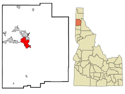
| State | Idaho |
| County | Kootenai |
| Founded | 1878 |
| Incorporated | 1887 |
| Government | |
| - Mayor | Sandi Bloem (R) |
| Area | |
| - City | 13.9 sq mi (35.2 km2) |
| - Land | 13.1 sq mi (34.0 km2) |
| - Water | 0.46 sq mi (1.2 km2) |
| Elevation | 2,188 ft (667 m) |
| Population (2007) | |
| - City | 43,683 |
| - Density | 2,628.9/sq mi (1,058.6/km2) |
| - Metro | 131,507 |
| Time zone | Pacific (UTC-8) |
| - Summer (DST) | Pacific (UTC-7) |
| Area code(s) | 208 |
| FIPS code | 16-16750 |
| GNIS feature ID | 0379485 |
| Website | www.coeurdaleneidaho.org |
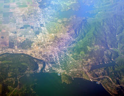
Coeur d'Alene (English: Heart of an Awl (Cœur being French for 'heart', and Alène meaning 'awl'), pronounced /ˌkɔr dəˈleɪn/) is the largest city and county seat of Kootenai County, Idaho, United States.[1] It is the principal city of the Coeur d'Alene Metropolitan Statistical Area. As of the 2000 census the population of Coeur d'Alene was 34,514 (2006 estimate: 41,328).[2] The city is located about 30 mi (48 km) east of the larger Spokane, Washington, which combined with Coeur d'Alene and northern Idaho has population of 590,617.[3] Coeur d'Alene is the largest city in the northern Idaho Panhandle while also an offshoot of Spokane.
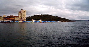
The city of Coeur d'Alene has grown significantly in recent years in part because of a substantial increase in tourism, encouraged by several resorts in the area. Barbara Walters called the city "a little slice of Heaven" and included it in her list of most fascinating places to visit. On November 28, 2007, Good Morning America broadcast the city's Christmas Lighting Ceremony because its display is among the largest in the country. Coeur d'Alene is also located near two major ski resorts with Silver Mountain Resort to the east in Kellogg and Schweitzer Mountain Ski Resort to the north in Sandpoint. Coeur d'Alene is located on the north shore of Lake Coeur d'Alene, 25-mile (40 km) in length. Locally, Coeur d'Alene is known as the "Lake City," or simply called by its initials: "CDA".
Contents |
Geography
Coeur d'Alene is located at (47.692845, -116.779910),[4] at an elevation of 2,180 ft (660 m) above sea level.
According to the U.S. Census Bureau, the city has a total area of 21.8 sq mi (56 km2). 21.1 sq mi (55 km2) of it is land and .745 sq mi (1.93 km2) of it (3.46%) is water.
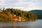
Coeur d'Alene sits on the western edge of the Coeur d'Alene National Forest. The city is surrounded by forest, which contains several lakes and campgrounds.

Climate
The average annual rainfall is 26 inches (66 cm) and the average annual snowfall is 49 inches (120 cm). The frost-free season runs about 120 days from mid-May to mid-September. The mean summer temperature is 82.1 °F (27.8 °C), and the mean winter temperature is 31.5 °F (-0.3 °C).[5]
| Climate data for Coeur d'Alene, ID | |||||||||||||
|---|---|---|---|---|---|---|---|---|---|---|---|---|---|
| Month | Jan | Feb | Mar | Apr | May | Jun | Jul | Aug | Sep | Oct | Nov | Dec | Year |
| Record high °F (°C) | 60 (15.6) |
62 (16.7) |
73 (22.8) |
94 (34.4) |
98 (36.7) |
102 (38.9) |
108 (42.2) |
109 (42.8) |
102 (38.9) |
87 (30.6) |
71 (21.7) |
60 (15.6) |
109 (42.8) |
| Average high °F (°C) | 35 (1.7) |
41 (5) |
49 (9.4) |
58 (14.4) |
68 (20) |
74 (23.3) |
83 (28.3) |
84 (28.9) |
74 (23.3) |
60 (15.6) |
43 (6.1) |
36 (2.2) |
59 (15) |
| Average low °F (°C) | 22 (-5.6) |
25 (-3.9) |
30 (-1.1) |
35 (1.7) |
43 (6.1) |
50 (10) |
55 (12.8) |
55 (12.8) |
47 (8.3) |
38 (3.3) |
30 (-1.1) |
25 (-3.9) |
38 (3.3) |
| Record low °F (°C) | -30 (-34.4) |
-29 (-33.9) |
-13 (-25) |
5 (-15) |
21 (-6.1) |
28 (-2.2) |
36 (2.2) |
32 (0) |
17 (-8.3) |
2 (-16.7) |
-13 (-25) |
-26 (-32.2) |
-30 (-34.4) |
| Precipitation inches (mm) | 3.28 (83.3) |
2.47 (62.7) |
2.34 (59.4) |
1.89 (48) |
2.25 (57.2) |
2.06 (52.3) |
1.02 (25.9) |
1.16 (29.5) |
1.12 (28.4) |
1.67 (42.4) |
3.35 (85.1) |
3.46 (87.9) |
26.07 (662.2) |
| Source: [6] | |||||||||||||
Demographics
| Historical populations | |||
|---|---|---|---|
| Census | Pop. | %± | |
| 1880 | 150 |
|
|
| 1890 | 491 | 227.3% | |
| 1900 | 508 | 3.5% | |
| 1910 | 7,291 | 1,335.2% | |
| 1920 | 6,447 | −11.6% | |
| 1930 | 8,297 | 28.7% | |
| 1940 | 10,049 | 21.1% | |
| 1950 | 12,198 | 21.4% | |
| 1960 | 14,291 | 17.2% | |
| 1970 | 16,228 | 13.6% | |
| 1980 | 19,913 | 22.7% | |
| 1990 | 24,563 | 23.4% | |
| 2000 | 34,515 | 40.5% | |
| Est. 2007 | 42,267 | 22.5% | |
| source:[7][8] | |||
As of the census[9] of 2000, there were 34,514 people, 13,985 households, and 8,852 families residing in the city. However, the 2006 estimate is that Coeur d'Alene is home to nearly 50,000 residents. The population density was 1,014.9/km². There were 14,929 housing units at an average density of 439.0/km². Coeur d'Alene's racial makeup was:
- 95.80% White
- 0.22% Black
- 0.77% American Indian
- 0.61% Asian
- 0.09% Pacific Islander
- 0.63% from other races
- 1.88% from two or more races
Hispanic or of any race were 2.70% of the population.
There were 13,985 households out of which 31.7% had children under the age of 18 living with them, 47.7% were married couples living together, 11.5% had a female householder with no husband present, and 36.7% were non-families. 28.2% of all households were made up of individuals and 11.3% had someone living alone who was 65 years of age or older. The average household size was 2.39 and the average family size was 2.93.
In the city the population was spread out with:
- 24.9% under the age of 18,
- 11.7% from 18 to 24
- 27.9% from 25 to 44
- 20.7% from 45 to 64
- 14.8% 65 years of age or older
The median age was 35 years. For every 100 females there were 93.7 males. For every 100 females age 18 and over, there were 89.3 males.
The median income for a household in the city was $33,001, and the median income for a family was $39,491. Males had a median income of $31,915 versus $21,092 for females. The per capita income for the city was $17,454. About 9.3% of families and 12.8% of the population were below the poverty line, including 13.5% of those under age 18 and 8.1% of those age 65 or over.
History

French Canadian fur traders allegedly named the local Indian tribe the Coeur d'Alene out of respect for their tough trading practices. Translated from French Cœur d'Alêne literally means "heart of the awl" which might mean "sharp-hearted" or "shrewd." Others interpret "Heart of the Awl" to translate to "Eye of the Needle", perhaps referring to the narrow passage through which the lake empties into the Spokane River on its way to the Columbia. However visitors from France say the term, "Coeur d' Alene" is an insult or swear word meaning the tribe of natives were mean spirited or pointed. The French point out that no matter how fanciful people want to describe the words, Coeur d' alene, it can only be translated as a mean or nasty curse, not anything kind or friendly.
The area was extensively explored by David Thompson of the Northwest Company starting in 1807. The Oregon boundary dispute (or Oregon question) arose as a result of competing British and American claims to the Pacific Northwest of North America in the first half of the 19th century.
The Oregon Treaty ended disputed joint occupation of the area when Britain ceded all rights to land south of the 49th parallel in 1846. When General William T. Sherman ordered a fort constructed on the lake in the 1870s, he gave it the name Fort Coeur d'Alene; hence the name of the city that grew around it. The name of the fort was later changed to Fort Sherman to honor the general. North Idaho College, a junior college, now occupies the site.
In the 1890s, the Coeur d'Alene district experienced two significant miners' uprisings.[10] In 1892, the union's discovery of a labor spy in their midst, in the person of sometime cowboy and Pinkerton agent Charlie Siringo, resulted in a shooting war between miners and the company. Years later Harry Orchard, who owned a share of the Hercules Mine in the nearby mountains before it began producing, and who later confessed to dynamiting a $250,000 mill belonging to the Bunker Hill Mining Company near Wardner during another miners' uprising in 1899, would also confess to a secret, brutal and little understood role in the Colorado Labor Wars before returning to Idaho to assassinate former Idaho Governor Frank Steunenberg.[11]
Economy
The city is the healthcare, educational, media, manufacturing, retail and recreation center for northern Idaho. Several mining firms are headquartered in the city. The Coeur d'Alene resort is a major employer. The U.S. headquarters of The Pita Pit is located in Coeur d'Alene.[12]
Infrastructure
Healthcare
Kootenai Medical Center is the primary medical center serving the Coeur d'Alene and north Idaho area. With over 1700 employees, is also the largest employer in Kootenai County.
Education
Coeur d'Alene School District 271
The Coeur d'Alene School District 271 serves 10,300 students with its two high schools, three middle schools, an alternative high/middle school, a dropout retrieval school and 10 elementary schools. The district has a dedicated staff of 550 teachers, 47 administrators and 552 support personnel to provide quality education for the Coeur d'Alene, Hayden and Dalton communities. All schools are accredited and two high schools and one middle school have merit status.
District staff and students have received numerous state and regional awards. Those include a Student Council of Excellence award for Lake City High School and a second place School of Excellence award for Coeur d'Alene high School from the Idaho High School Activities Association. The District is especially proud to be home of five of the past 10 Idaho Teachers of the Year. For the 11th year, the District has received a "What Parents Want" designation from SchoolMatch, a national family relocation business.
District 271 provides myriad learning and enrichment opportunities to help students meet Idaho's Performance Standards. In addition to numerous Honors and Advanced Placement courses, Coeur d'Alene and Lake City High Schools began offering the International Baccalaureate Diploma Program, and two of the elementary schools are implementing the IB Primary Years Program. Coeur d'Alene High School no longer offers the International Baccalaureate Diploma Program because of a lack of funding.
District 271 students who qualify are also eligible for dual enrollment with North Idaho College and advanced technical and specialized courses at Riverbend Professional Technical Academy in Post Falls.
A partnership with the City of Coeur d'Alene Police Department provides five School Resource Officers. Through an alliance with Kootenai Medical Center, the District is served by seven school nurses.
Coeur d'Alene also boasts a highly successful Charter school which has won numerous academic awards including being recognized for Best Overall Academic Performance in the State of Idaho by BusinessWeek, as well as being listed as one of the best 100 high schools to enroll into in America. Its ISAT, PSAT, SAT, ACT, and AP tests scores are significantly higher than its local counterparts as well as having better SAT scores in general then those of other national high schools. Charter itself has an extremely high rate of its graduates attending post-secondary schools. Its teaching curriculum focus heavily on setting higher college-preparatory standards then many other schools, with a strong emphasis on teaching the Latin language. The reading and math levels of the attending students score generally a level higher than required in the state of Idaho. The school also enforces a strict dress code policy on all enrolled students to maintain a professional academic atmosphere. Coeur d'Alene Charter Academy is a regular middle–high school publicly funded with open admission to any students residing in the state of Idaho, not just those restricted to a particular district of the county. However, public transportation is not provided to the school. The Coeur d'Alene Charter Academy is currently undergoing expanding into neighboring lots for the purpose of adding additional classrooms.
Transportation
Roads and highways
Coeur d'Alene is accessed from Interstate 90 at Exits 11 though 15. The greater Coeur d'Alene area is almost entirely dependent upon private automobiles for transportation. Combined with the city's rapid growth since 1990, relative congestion now occurs on a significant portion of the area highways, notably U.S. 95 between Northwest Blvd. north to Hayden, and on several under-developed arterial streets such as Atlas, Ramsey, and Government Way. Before the construction of I-90, the city was served by U.S. Route 10, which runs through downtown. This route is Northwest Boulevard and Sherman Avenue. The former US 10, between I-90 exits 11 and 15, is now designated as Interstate 90 Business.
Public transportation
Free public bus service is available to area residents. Called Citylink Transit all buses are wheelchair accessible, and can transport up to four bicycles. The buses operating in the urbanized area of Kootenai County leave the Riverstone Transfer Station every eighty minutes, seven days a week, including holidays. The bus system comprises five separate routes.
- Urban Route A - Serves State Line, Post Falls and Coeur d'Alene.
- Urban Route B - Serves Post Falls, Hayden and West Coeur d'Alene.
- Urban Route C - Serves Downtown Coeur d'Alene, Fernan and Hayden.
- Rural Route - Serves the towns of Worley, Plummer, Tensed and DeSmet.
- Link Route - Connects the two transfer stations at Riverstone and Worley.
Commercial
Coeur d'Alene's retail has expanded greatly in recent years with the opening of new stores and entertainment venues. Coeur d'Alene's Riverstone development houses a 14 theater Regal Cinemas, condominiums, a Hampton inn, a park, restaurants, and local retailers. The North Idaho Centennial Trail bike path cuts through the Riverstone complex alongside an abandoned railroad right of way. The Citylink transit system adjoins the northwest entrance of the Riverstone complex. Giant statues of bird feathers line Northwest Boulevard celebrating the rich native American heritage of Coeur d'Alene. Several art galleries and cafes sit along Sherman Avenue, Coeur d'Alene's main street. During summer, artists and musicians frequent Sherman Square.
Airports
The closest major airport serving Coeur d'Alene and North Idaho is the Spokane International Airport which is served by nine airlines and is located 40 miles (64 km) to the west in Spokane, Washington. Coeur d'Alene also has Pappy Boyington Field Airport (KCOE), which is a general aviation airport located in Hayden, north of the city near U.S. 95.
Utilities
The city of Coeur d'Alene provides for municipal water, sewer & stormwater management, street lighting, and garbage collection. Frontier Communications provides local phone service, while Time Warner Cable provides cable television. Avista Utilities provides natural gas and electricity to the area.
Events and attractions
- Coeur d'Alene is the home of Ironman Coeur d'Alene, which started in 2003. This Ironman Triathlon is held each year on the fourth Sunday in June and starts at the Coeur d'Alene resort as triathletes start their day with a 2.4-mile (3.9 km) swim in Lake Coeur d'Alene, followed by a 112-mile (180 km) bike, finishing with a 26.2-mile (42.2 km) run.[13]
- Coeur d'Alene holds the Christian Youth Theater CYT North Idaho headquarters.
- Annually in June, CdA hosts "Car d' Alene," where all the hot cars both new and old, come out to display themselves for admiration and bragging rights.[14]
- The local college art program had a campaign called "Moose on the Loose," where local artists and college art students painted and decorated a dozen or so life size moose statues with various colors and accessories. After their beautification, they were auctioned off to local businesses as a fundraiser. Their locations range from downtown near Sherman Ave. to Government Way on the CdA/Hayden boundary. The moose have become both a town landmark and a popular scavenger hunt item.[15]
- Coeur d'Alene has become a destination for golf enthusiasts. The Coeur d'Alene Resort Golf Course is considered one of the best in the United States. Its 14th hole features the world's only movable floating green.[16]
- Coeur d'Alene is a shortlisted town, for when APEC next meet in the U.S.
- The North Idaho Centennial Trail passes through Coeur d'Alene.
- Coeur d'Alene and the surrounding area also provides many outdoor recreational opportunities, such as: mountain biking, hiking, camping, fishing, hunting, etc. The Mountain Air Resort is just to the north of town and provides natural style camping,hiking,biking,fishing. Visitors can stay and enjoy the "Real" North Idaho. A naturalist style forest experience.
- Coeur d'Alene is home of Snake Pit Derby Dames; an all-female flat track roller derby league. The competitive season is March-November and Bouts (matches) draw large crowds.[17]
- Every year in November, the Friday after Thanksgiving marks the start of Coeur d'Alene's Christmas Lighting Ceremony including a parade, fireworks and special holiday candles given out by the local downtown businesses.
In popular culture
- In the book Walk Two Moons, Coeur d'Alene is a stop on the main character Salamanca Tree Hiddle's trip.
- Coeur d'Alene is one of the spots that Antagonist Morrison, used as a hide out and place to get some ammunition. This was in Tom Clancy's 4th book in the Net Force Series, Breaking Point (ISBN 0-425-17693-2). They hide out in an Aryan Nations compound (now destroyed) in Hayden Lake (mentioned as Coeur d'Alene).
- Coeur d'Alene was mentioned in Sam Bourne's novel: The Righteous Men as a spot that the main character quickly drove past. It is stated that Coeur d' Alene is the home of the Aryan Nations. However, the Aryan Nations' home was in nearby Hayden Lake, not Coeur d'Alene specifically. The compound is no longer in Hayden Lake because of a heated lawsuit and the bankruptcy of the Aryan Nations.
- Coeur d'Alene is the fictional home of Lisa Kimmel Fisher (character played by actress Lily Taylor) from the HBO series Six Feet Under.
- Coeur d'Alene is mentioned in the lyrics "Everything is frozen north of Wichita, I'm standing in this truck stop in Coeur d'Alene" in the Gary Jules song "Wichita."
- Coeur d'Alene is mentioned in the song Wings by Josh Ritter.
- Iris DeMent's song, "Easy's Gettin' Harder Every Day", from her 1994 album, My Life, features a protagonist who laments that she will "never make it to Coeur d'Alene".
- Listed as one of the places to visit in Patricia Schultz's book 1,000 Places to See Before You Die.[18]
- The main character of Neil LaBute's play Wrecks is originally from Coeur d'Alene.[19]
- The main characters in the film "Smoke Signals", based on the Sherman Alexie story, are Indians of the Coeur d'Alene tribe.
- The twelfth track of Alter Bridge's third album AB III is named after the city.
- The setting for the children's book "Mudgy & Millie," by Susan Nipp. Illustrated by Charles Reasoner. http://www.mudgyandmillie.com/
Notable people
- Academy Award winning actress Patty Duke has lived in Coeur d'Alene since the mid-1990s with her husband, Michael Pearce.
- Coeur d'Alene is the birthplace of Milwaukee Bucks point guard Luke Ridnour.[20]
- Dorthea Dahl, Norwegian-born American writer, wrote and published her collections of short stories and her novel while residing near Coeur d'Alene.
- World War II flying ace Colonel Gregory "Pappy" Boyington was born in Coeur d'Alene on December 4, 1912 and was a member of the AVG (Flying Tigers) and later the commander of the famous Black Sheep Squadron.[21] The local airport is now named in his honor.
- Ellen Travolta, oldest sibling of John Travolta currently resides in Coeur d'Alene.
- Trevor Prangley, pro Mixed Martial Artist with a background in wrestling and is a former fighter in the UFC. His current fight record is 22 wins, 6 losses, 1 draw. He was born in South Africa and now resides in Coeur d'Alene.
Sister cities
Coeur d'Alene has one sister city:
 - Cranbrook, British Columbia (Canada)
References
- ↑ "Find a County". National Association of Counties. http://www.naco.org/Template.cfm?Section=Find_a_County&Template=/cffiles/counties/usamap.cfm. Retrieved 2008-01-31.
- ↑ Table 4: Annual Estimates of the Population for Incorporated Places in Idaho, Listed Alphabetically: April 26, 2000 to July 1, 2006 (SUB-EST2006-04-16) Accessed 16 July 2007
- ↑ "Annual Estimates of the Population of Metropolitan and Micropolitan Statistical Areas: April 1, 2000 to July 1, 2007 (CBSA-EST2007-01)" (CSV). 2007 Population Estimates. United States Census Bureau, Population Division. 2007-03-27. http://www.census.gov/popest/metro/tables/2007/CBSA-EST2007-07.csv. Retrieved 2007-03-27.
- ↑ "US Gazetteer files: 2000 and 1990". United States Census Bureau. 2005-05-03. http://www.census.gov/geo/www/gazetteer/gazette.html. Retrieved 2008-01-31.
- ↑ Coeur d'Alene Weather
- ↑ "Average Weather for Coeur d'Alene, ID - Temperature and Precipitation". Weather.com. http://www.weather.com/outlook/travel/businesstraveler/wxclimatology/monthly/graph/USID0048?from=36hr_bottomnav_business. Retrieved November 3, 2009.
- ↑ Moffatt, Riley. Population History of Western U.S. Cities & Towns, 1850-1990. Lanham: Scarecrow, 1996, 91.
- ↑ "Subcounty population estimates: Idaho 2000-2007" (CSV). United States Census Bureau, Population Division. 2009-03-18. http://www.census.gov/popest/cities/files/SUB-EST2007-16.csv. Retrieved 2009-05-03.
- ↑ "American FactFinder". United States Census Bureau. http://factfinder.census.gov. Retrieved 2008-01-31.
- ↑ Roughneck—The Life and Times of Big Bill Haywood, Peter Carlson, 1983, pages 53-54.
- ↑ Roughneck—The Life and Times of Big Bill Haywood, Peter Carlson, 1983, pages 91-92.
- ↑ "Contact Pita Pit." The Pita Pit. Retrieved on February 23, 2010.
- ↑ http://www.ironmancda.com/
- ↑ http://www.coeurdalene.org/calendardetail.asp?event_id=2824&view=&date=6/13/2008
- ↑ http://www.cdaid.org/index.php?module=pagemaster&PAGE_user_op=view_page&PAGE_id=122
- ↑ http://www.cdaresort.com/resort/
- ↑ http://www.northidahorollerderby.com
- ↑ http://www.43places.com/places/view/640846/lake-coeur-dalene-idaho
- ↑ LaBute, Neil. Wrecks and Other Plays. New York: Faber and Faber, 2007. 9.
- ↑ http://sports.yahoo.com/nba/players/3717
- ↑ http://www.arlingtoncemetery.net/ghboying.htm
External links
- Coeur d'Alene Visitor's and Convention Bureau Official Site
- Coeur d'Alene Idaho Downtown Association Official Web Site
- North Idaho Centennial Trail Official Web Site
- Coeur d'Alene Parks Foundation
- Coeur d'Alene Economic Development Corporation - Jobs Plus
- Official website of the city of Coeur d'Alene
- Coeur d'Alene Press
- National Weather Service - NWS Spokane Office
- Informative Tubbs Hill Website
|
|||||||||||||||||
|
||||||||||||||||||||